There are 26 sedimentary basins in India, covering a total area of 3.4 million square kilometers. The area is spread across on land, shallow water up to 400-meter water depth and deepwater farther up to Exclusive Economic Zone (EEZ). Of the total sedimentary area, 49% of the total area is located on land, 12% in shallow water, and 39% in deepwater areas. There are 16 on-land basins, 7 located both on land and offshore, and 3 completely offshore. Tectonically, these basins are classified into 3 groups, based on origin from rifting (intra-cratonic and peri-cratonic), plate collision, and crustal sag.
These basins are divided into three categories based on the maturity of hydrocarbon resources as under:
• Category-I: Basins, which have reserves and already producing.
• Category-II: Basins, which have contingent resources pending commercial production
• Category-III Basins, which have prospective resources awaiting discovery
Map of Indian Basins
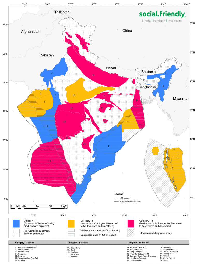
Category I Basins
Based on conventional resource potential, 7 basins are grouped under Category-I covering 30% of the total basinal area and holding 85% of the total unrisked conventional hydrocarbon in place of 41.8 billion ton oil and oil-equivalent gas. These 7 basins are namely Krishna-Godavari (KG), Mumbai Offshore, Assam Shelf, Rajasthan, Cauvery, Assam-Arakan Fold Belt, and Cambay. These basins are fairly appraised to the extent of 47% of the country’s total appraised area (1.6 million square kilometers) with 65% of the country’s total active operational area (0.3 million square kilometers).
Category II Basins
Similarly, Category-II basins cover 23% of the total basinal area, holding 9% of the total hydrocarbon in place. Five basins fall in this category and those are namely Saurashtra, Kutch, Vindhyan, Mahanadi, and Andaman. These basins are moderately appraised to the extent of 22% of the country’s total appraised area with 26% of the country’s total active operational area.
Category III Basins
Further, Category-III basins cover 47% of the total basinal area, holding 6% of the total hydrocarbon in place. Fourteen basins fall in this category and those are namely Kerala-Konkan, Bengal-Purnea, Ganga-Punjab, Pranhita-Godavari(PG), Satpura-South Rewa-Damodar, Himalayan Foreland, Chattisgarh, Narmada, Spiti-Zanskar, Deccan Syneclise, Cuddapah, Karewa, Bhima-Kaladgi, and Bastar. These basins are appraised to the extent of 31% of the country’s total appraised area with 9% of the country’s total active operational area.
The grouping of the basins under the category is dynamic, a Category III basin can be upgraded to II in case there is a discovery (recent instance of Bengal-Purnea basin) or Category II to I, if discoveries are developed for commercial production (Kutch/ Saurashtra basin could be the next as few FDPs already approved). For unconventional resources, the above category will have a completely different basin grouping. For example, CBM gas is currently produced from the Damodar sub-basin of Satpura-South Rewa-Damodar basin, which is a Category III basin for conventional resources, however by virtue of commercial gas production, the basin will be deemed Category I for unconventional resources.